The answer might surprise you.
Every piece of land has a hidden story. Some reveal clean ownership. Some reveal a dispute nobody mentioned. Some reveal a flood risk no one thought to check. Some reveal a government acquisition order the seller never brought up. The only question is what yours will reveal.
A taste of what a scan reveals. Real results, real pilot, coming to your plot soon.
You don't have to be buying land to be curious about it. Pick the one that came to mind first.
Would a scan confirm your ownership, or reveal something nobody told you?
Is it still registered the way you think it is?
A scan could settle the argument before it settles in court.
Know what it's hiding before you pay for it.
Ever wondered who actually owns it?
Whichever one you picked, that's the one to scan first.
Join the Waitlist →Buying land in Nigeria shouldn't require insider connections, months of paperwork, or blind trust in a handshake.
TruPlot brings ownership records, government acquisition status, and flood risk together in one scan, so you know what a plot is really like before it costs you anything.
Drop a pin. Set your plot size. See what comes back.
Ownership, C of O status, zoning, and legal disputes, piloting now in Oyo State.
Elevation, drainage, and historical flood data for any location in Nigeria.
Built to plug into official land records as our government partnerships come online.
Join the waitlist to be first when we invite testers into the live pilot.
We're still building, so consider this a look behind the curtain. The screens below are from our real, working prototype.
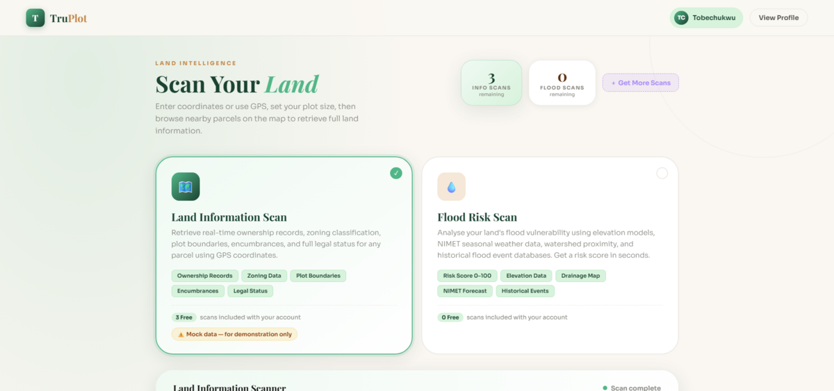
Choose a Land Information Scan or a Flood Risk Scan right from your dashboard.
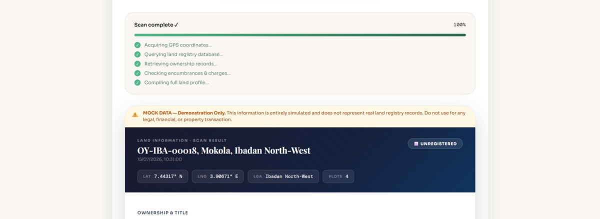
Ownership status, zoning class, legal status, and any encumbrances on record, laid out clearly.
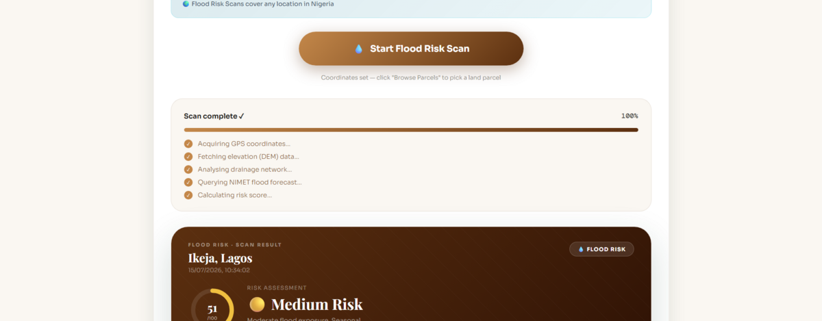
A risk score out of 100, built from elevation, drainage, and past flood events near the plot.
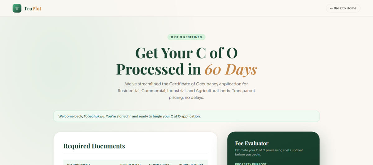
See the exact documents and fees required before you even start your application.
Land Information Scan results shown here use simulated data while we finish connecting to official Oyo State records. Flood Risk Scan results are drawn from real elevation and weather data.
From dropping a pin to reading a full land profile, here's exactly what happens.
Choose a Land Information Scan to check ownership and legal status, or a Flood Risk Scan to find out if the land is safe to build on. You can run either, or both, on the same plot.
Use your phone's GPS or type in coordinates by hand. Then tell us how much land you're checking, either by plot count or hectares, so we know exactly how wide to search.
TruPlot loads the parcels around your pin so you can pick the exact plot you're interested in, not just an approximate area.
Once you hit scan, we go to work: querying the land registry, pulling ownership records, and checking for encumbrances and charges. It takes seconds, not the weeks a manual search would take.
You get a clear profile you can act on: registered owner, C of O status, zoning class, tenure type, distance to infrastructure, and any disputes on record. For flood scans, you'll see a plain risk verdict too:
Download the report, share it with whoever you're buying with, or use it to decide your next move, whether that's walking away or starting a Certificate of Occupancy application.
We're recording walkthroughs with real land buyers as they test the pilot. They'll go live here as they're ready. Here's what to expect.
A buyer in Ibadan scans a plot and reads the ownership report before agreeing to inspect it in person.
A first-time buyer checks a plot's flood score before committing to a purchase.
A walkthrough of the guided C of O application, from required documents to the fee evaluator.
Millions of naira are lost every year because buyers cannot easily check ownership, government acquisition, or environmental risk before making payment.
Buyers unknowingly purchase land earmarked for government use and only find out when the bulldozers arrive. TruPlot checks official acquisition records so you know before you pay.
Land that looks fine in the dry season can become a disaster in the rains. TruPlot checks flood probability and environmental risk for any plot before a single naira changes hands.
Forged title documents and Omo Onile schemes cost Nigerians billions every year. TruPlot is being built to authenticate title documents against government databases, catching fraud before it costs you.
Outstanding Land Use Charges, months-long registration delays, and paper-based processes trap buyers in disputes after purchase. TruPlot is designed to surface hidden liabilities before you commit.
Help every Nigerian verify land before spending their life savings.
Help every Nigerian verify land before spending their life savings, using government-linked records anyone can access.
A future where buying land in Nigeria is as safe and transparent as making a bank transfer, for every buyer, not just the privileged few.
Launching in Nigeria and expanding across all 36 states and the FCT, bringing land safety to every buyer in the country.
These aren't slogans on a wall. They are design constraints. Every product decision at TruPlot is tested against them.
We only surface data we can verify. No guesses, no approximations. If our system cannot verify a claim, we say so. The integrity of our reports is non-negotiable.
Institutional-grade land verification should not be a luxury. TruPlot is designed to require nothing but a smartphone.
We tell the truth about risks even when it costs us a transaction. If a plot is dangerous, our report will say so clearly. We do not hedge to protect commissions.
We believe land verification only works long-term when it's built alongside government, not around it. Our platform is designed to strengthen official land administration capacity and boost state IGR, making the relationship genuinely mutual.
From the moment you spot a plot to the day you hold your title, TruPlot is built to cover every step.
Our guided Certificate of Occupancy flow, complete with a live fee evaluator, is already built and running as a prototype. We're now working on the government data partnerships needed to connect it to official C of O records, survey plans, and acquisition maps.
Choose a Flood Risk Scan or a Land Information Scan, drop a pin, and see a full land profile in seconds. Both scans are already live in our prototype. Flood Risk pulls real elevation and weather data for anywhere in Nigeria; Land Information Scan uses simulated data while we finish connecting to Oyo State records.
Every property on the TruPlot marketplace passes our dual verification before listing. Buyers browse with full confidence. Agents earn the "Verified Safe" badge to build trust and close sales faster. Planned for post-pilot.
When a "Caution" flag needs expert resolution, Pro Connect links you with verified Surveyors, Architects, and Consultants. Payments held in escrow until service is delivered. Planned for post-pilot.
Join land buyers and agents across Nigeria waiting for TruPlot to go live.